↓
 

Bridgeport Land Surveying

Local Land Surveyors in Bridgeport, WV

Bridgeport Land Surveying
  • Home
  • ALTA Survey
  • Boundary Surveying
  • Construction Survey
  • Drone LiDAR Mapping
  • Elevation Certificate
  • Land Surveying
  • Topographic Survey
  • Blog
  • Contact Us
Home - Page 2 << 1 2 3 4 … 7 8 >>

Post navigation

← Older posts
Newer posts →

Are Property Lines on Google Maps Accurate?

Bridgeport Land Surveying Posted on May 25, 2026 by BridgeportSurveyorMay 27, 2026
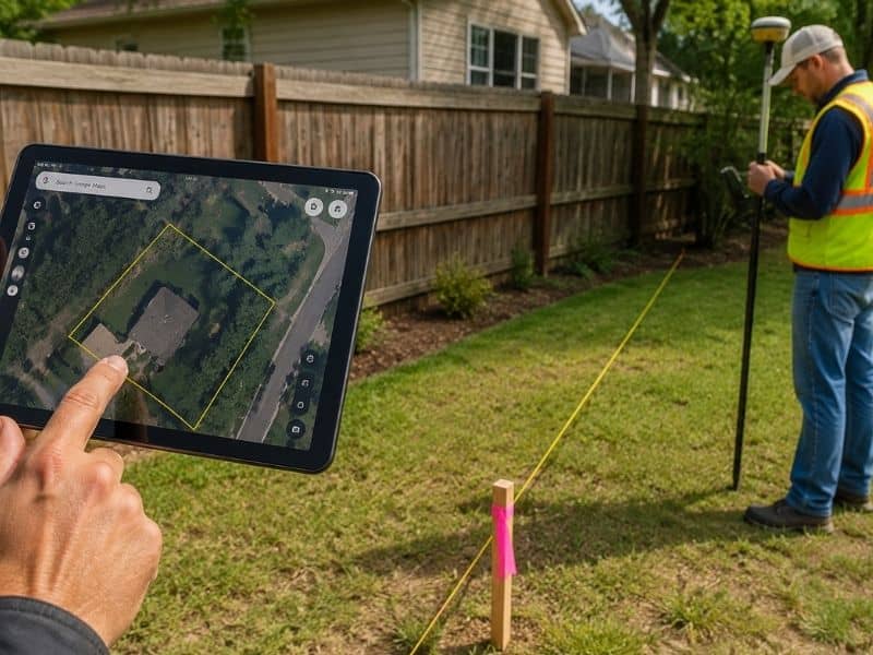
Land surveyor checking a residential property boundary while comparing survey markers with a digital property map

The short answer is no. Google Maps does not show accurate property lines. The boundary lines you see on Google Maps or Google Earth are pulled from public GIS (Geographic Information System) databases maintained by county tax offices. These records are meant for general reference only, and they carry no legal weight. If you are making decisions about your land based on what you see in Google Maps, you could be setting yourself up for a costly mistake.

What Does Google Maps Actually Show?

When you zoom into a property on Google Maps, you may notice faint lines outlining what looks like your lot. Many people assume these are their official property lines. In reality, they are rough approximations pulled from county tax assessor and GIS records.

These databases were not designed for land surveying. They exist to help government offices track property ownership for tax purposes. The data is often digitized from older plat maps, and counties update it at different rates. Some areas refresh their GIS records regularly, while others may go years without corrections. By the time that data reaches Google Maps, it can be significantly out of date.

Why These Lines Cannot Be Trusted

There are three main reasons why Google Maps property lines are not reliable for legal or construction purposes.

The data is not survey-grade. A professional land survey uses precision instruments such as GPS receivers and total stations to measure land with centimeter-level accuracy. GIS parcel data does not come close to that level of precision. The lines in Google Maps are digitized estimates, not field measurements.

The information is often outdated. If a property was subdivided, re-platted, or had a boundary change recorded, that update may not appear in the county GIS database for months or even years. Google Maps simply reflects whatever the county has on file, including errors.

It has no legal standing. No court, title company, lender, or building department will accept a Google Maps screenshot as proof of a property boundary. The only document that legally defines where your property begins and ends is a survey prepared and sealed by a licensed professional land surveyor.

How Far Off Can the Lines Be?

The error can range from a few feet to several dozen feet, depending on the area and the age of the records.

In urban and suburban neighborhoods, Google Maps lines might look close to correct but could still be off by 2 to 10 feet. That may not sound like much, but a 5-foot error near a property line can mean the difference between a legal fence and an encroachment on your neighbor’s land.

In rural areas, errors are often larger. Older properties described by metes and bounds, a method that uses directions and distances rather than a standard grid, are especially prone to misrepresentation in GIS systems. Errors of 20 to 50 feet are not unusual for rural parcels.

The Risks of Relying on Google Maps

Using Google Maps to make decisions about your property can lead to serious problems. Here are the most common issues homeowners face:

  • Fence and structure encroachments. Building on land you believe is yours, but is not, can result in removal orders and legal disputes with your neighbor.
  • Permit denials. Building departments require structures to meet setback requirements measured from legal property lines. Google Maps lines are not accepted for this purpose.
  • Failed real estate closings. Buyers and lenders require accurate surveys before a sale is finalized. A Google Maps printout will not satisfy that requirement.
  • Neighbor disputes. Assumptions based on Google Maps frequently lead to disagreements that require surveyors or attorneys to resolve, which adds time and expense.

The Right Way to Find Your Property Lines

The only reliable and legally recognized way to find your property lines is to hire a licensed professional land surveyor to perform a boundary survey.

A boundary survey involves researching your deed, reviewing recorded plat maps, locating existing survey monuments in the field, and using precision equipment to measure and confirm your property corners. At the end of the process, the surveyor will mark your corners with physical monuments such as iron pins or concrete posts. You will also receive a survey map that can be recorded with your county.

This is the document that holds up in court. It is what your title company, lender, and building department will accept. No online tool or satellite image can replace it.

When Should You Order a Boundary Survey?

You should consider getting a boundary survey in these situations:

  • Before purchasing a piece of land or vacant property
  • Before building a fence, shed, garage, or addition near your property line
  • When a neighbor questions where your boundary is
  • When applying for a building permit that requires setback documentation
  • When dividing or selling part of your land
  • When resolving a title issue during a real estate transaction

Frequently Asked Questions

Can I use Google Earth instead of Google Maps for property lines? 

No. Google Earth uses the same GIS parcel data and has the same limitations. Neither platform provides legally accurate boundary information.

Are county GIS websites more accurate than Google Maps? 

County GIS portals are often more current than Google Maps, but they are still administrative records, not survey-grade data. They should not be used for construction, legal, or real estate decisions.

How much does a boundary survey cost? 

Costs vary based on parcel size, terrain, and the complexity of the deed description. Most residential boundary surveys in the United States range from $500 to $2,500. Contact Bridgeport Land Surveying for a quote specific to your property.
Posted in land surveying

Property Easements Explained: What Every Landowner Should Know

Bridgeport Land Surveying Posted on May 22, 2026 by BridgeportSurveyorMay 22, 2026
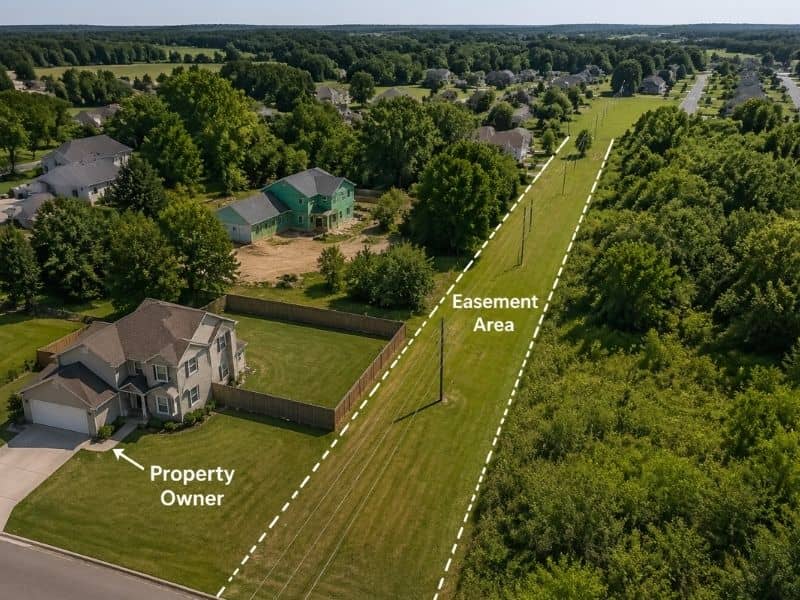
Aerial view of a residential property easement with visible boundary lines and utility access area near a surveyed backyard

If you own land or are planning to buy property, there is one legal term you need to understand before signing anything: a property easement. Easements affect more than 30% of residential properties in the United States, yet most homeowners have never heard of them until a problem comes up. Knowing what they are and how they work can save you a lot of stress and money down the road.

What Is a Property Easement?

A property easement is a legal right that allows a person or company to use part of someone else’s land for a specific purpose, such as running utility lines or accessing a road. The landowner keeps ownership but cannot block the easement holder from using that portion of the property.

An easement does not mean someone else owns your land. It simply means they have the legal right to use a portion of it for a stated reason. For example, your electric company may have an easement to run power lines across the back of your yard. You still own the land, but you cannot build a structure that blocks those lines.

Easement vs. Right-of-Way: What Is the Difference?

These two terms are often used together, but they are not the same. A right-of-way is a type of easement that gives someone the right to travel through your property, usually along a set path. An easement is the broader legal term that covers all types of permitted use, not just travel. Think of a right-of-way as one branch of the easement family.

Types of Property Easements

The four most common types of property easements are utility easements, access easements, prescriptive easements, and drainage easements. Each type gives different rights to the holder and places different limits on what the property owner can do with their land.

Utility Easements

Utility easements are the most common type. They allow power, gas, water, and cable companies to install and maintain lines or pipes on your land. These easements cover millions of miles of private land across the country, according to the U.S. Energy Information Administration. As a landowner, you cannot build permanent structures over these areas.

Access Easements

An access easement gives someone the right to cross your property to reach another location. This is common in rural areas where one property is landlocked and the only way in or out is through a neighbor’s land.

Prescriptive Easements

A prescriptive easement is created when someone uses your land openly and without permission for a long period of time. If they do this consistently, they may earn the legal right to continue using it. The length of time required varies by state, so checking your local laws is important.

Drainage Easements

Drainage easements allow water to flow across your property in a controlled way. Local governments often set these up to manage stormwater and prevent flooding in surrounding areas.

How to Find Out If Your Property Has an Easement

To find out if your property has an easement, check your property deed, review the plat map at your county recorder’s office, request a title search, or hire a licensed land surveyor. Easements are recorded in public land records and will appear on a boundary survey.

Here are the most reliable steps to take:

  • Review your property deed for any recorded easements
  • Visit your county recorder’s or assessor’s office and request the plat map
  • Ask a title company to run a full title search
  • Hire a licensed land surveyor to conduct a boundary or ALTA survey

An ALTA/NSPS Land Title Survey is the only survey type that officially identifies and maps all easements on a parcel according to national standards. It is the most thorough option available.

How Easements Affect Property Value

Easements can reduce property value by limiting how you use or develop your land. According to the Appraisal Institute, properties with unresolved easement issues can lose between 5% and 40% of their appraised value, depending on the type and location of the easement.

Easement disputes are also among the top five causes of real estate litigation in the United States, according to the National Association of Realtors. This is why it is important to know about any easements before you buy. A large utility easement running through the middle of a lot, for example, can prevent you from adding to your home or putting up a fence. These restrictions directly affect what buyers are willing to pay.

Not all easements lower property value, though. A small access easement along the edge of your lot may have little to no financial impact if it does not interfere with your plans for the land.

Can a Property Easement Be Removed?

Yes, a property easement can be removed, but only under specific legal conditions. These include a mutual agreement between both parties, the easement’s purpose no longer existing, or a court ruling it invalid. Simply wanting to remove an easement is not enough on its own.

Here are the main ways an easement can end:

  • Both parties agree in writing to terminate it
  • The purpose of the easement no longer exists, for example, a utility line is permanently removed
  • The same person buys both properties, merging ownership into one
  • A court rules the easement was never valid or has since expired

Before attempting to remove an easement, speak with a real estate attorney and a licensed land surveyor. They can review the recorded documents and advise you on the best path forward.

Frequently Asked Questions

Do easements transfer when a property is sold? 

Yes. In most cases, easements are attached to the land, not the owner. This means they carry over to the new owner when a property changes hands. This is why reviewing easements during the buying process is so important.

Can I build a fence on an easement? 

It depends on the type of easement. Most utility easements prohibit permanent structures, including fences. Access easements may allow fencing as long as a gate is provided. Always check the specific terms of the easement before building anything.

Who is responsible for maintaining an easement area? 

The easement holder is usually responsible for maintaining the area they use. However, the property owner is still expected to keep up the surrounding land.

Are easements the same as encroachments? 

No. An easement is a legal right granted to use someone’s land. An encroachment happens when a neighbor builds or extends a structure onto your property without permission. They are two separate legal issues with very different solutions.

How long does it take to resolve an easement dispute? 

It varies. Simple disputes settled between neighbors can take a few weeks. Cases that go to court can take months or longer. Working with a qualified land surveyor and a real estate attorney early in the process can help speed things along.

Posted in boundary surveying | Tagged boundary surveying

Welcome to Bridgeport Land Surveying

Bridgeport Land Surveying Posted on August 18, 2017 by BridgeportSurveyorMarch 24, 2020

Your Final Stop for ALL of Your Survey Needs!                                         Contact us today for a free quote!

This site is intended to provide you with information on Land Surveying in the Bridgeport, WV and Harrison County area of West Virginia. If you’re looking for a Bridgeport Land Surveyor, you’ve come to the right place. If you’d rather talk to someone about your land surveying needs, please call our local number at (304) 933-6002 today. For more information, please continue to read.

land surveyingLand Surveyors are professionals who make precise measurements to determine the size and boundaries of a piece of real estate.  While this is a simplistic definition, boundary surveying is one of the most common types of surveying related to home and land owners. If you fall into the following categories, please click on the appropriate link for more information on that subject:

Bridgeport Land Surveying services:

    1. I need to know where my property corners or property lines are. (Boundary Survey)
    2. I have a loan closing or re-finance coming up on my home in a subdivision. (Lot Survey)
    3. I need a map of my property with contour lines to show elevation differences for my architect or engineer. (Topo Survey)
    4. I’ve just been told I’m in a flood zone or I’ve been told I need an elevation certificate in order to obtain flood insurance or prove I don’t need it. (Flood Survey)
    5. I’m purchasing a lot/house in a recorded subdivision. (Lot Survey – See Boundary Survey if you’re not in a subdivision.)
    6. I’m purchasing a larger tract of land, acreage, that hasn’t been subdivided in the past. (Boundary Survey)

Contact Bridgeport Land Surveying services TODAY at (304) 933-6002.

Posted in boundary surveying, elevation certificate, land surveying, land surveyor | Tagged boundary survey, Bridgeport Land Surveying, land surveyor, land surveyor bridgeport wv

Post navigation

← Older posts
Newer posts →
Get Quote Button
© Boxer Survey USA
Bridgeport Land Surveying

Bridgeport, West Virginia
Phone: (304) 933-6002

Web Development and SEO by:
AuburnBusiness.com, LLC


Privacy Policy | Terms of Use

The owner of this website, Boxer Survey USA, provides coordination of professional land surveying and engineering services in all 50 states. The professional surveying and engineering services provided to you will be conducted by fully licensed professionals in your state.

↑